I said in my last post that we drove around town on Friday and then went south to check out another local scenic attraction; Angel Peak (←click link for google images).
Before we went to Angel Peak, we spent a little time running around downtown Farmington looking for an ATM that didn’t charge fees and scouting out a couple potential dump stations to use on our way out of here. We were successful on the first mission (ATM) but not on the dump station because they all seemed to be in the wrong direction and/or they were not easily accessible. We decided to wait until we get to Page, AZ to dump unless something turns up along our route. Oh, and we also stopped at Burger King for a quick lunch and we went into a local RV supply store to see what they had. I’m running low on slide-out lubricant, but the store didn’t have anything that I liked.
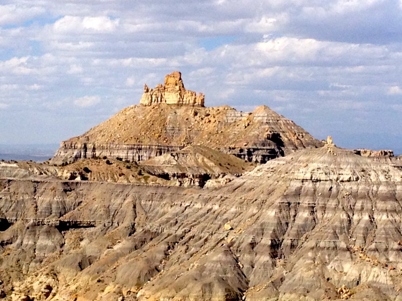
Angel Peak is indicated on the map (below) by the yellow arrow. The turn-off is about 15 miles south of Bloomfield on US-550. We passed this attraction on our way here from Santa Fe last Wednesday but didn’t stop.
It’s only a short drive off US-550 on County Road 7175 on a well-maintained gravel road to the first scenic overlook. But you have to travel another 6 miles to get to the campground.
Here’s the view(s) from one of the viewpoints about halfway to the campground:
We made it to the campground loop. Great views but, wow – was it ever windy! We’ve had great weather every day since we left Colorado Springs… so one day with gusty winds won’t make us complain too much 🙂
We stopped at most of the scenic viewpoints. But sometimes we didn’t even get out of the truck due to the high winds.
This viewpoint is called Castle Rock Overlook…
There’s even a well-placed bench on a trail that can be used to sit and ponder the meaning of life or whatever while you enjoy the scenery… But for us, it was too windy – poor little Coach might get blown away 🙁
Here’s what the Rand McNally RVND™ 7720 GPS displayed after we turned around at the campground loop and headed back out.
We drove back to the Elks Lodge. Here’s a view of the steep entrance to the Farmington Elks Lodge.
And we’re back from another day’s adventure.
We enjoyed another great dinner (filet-mignon) at the well-appointed lodge dining room and then hung out in the bar area to use the free Wi-Fi to upload and edit all the pictures for my last post. My Verizon JetPack MiFi plan is 20GB for $100 and we had used it all up this month a couple days ago. It resets again on the 2nd, but I wanted to get the post done before we headed to Lake Powell so I took advantage of the Elks free WiFi. Thanks Elks Lodge 1747!
Time to close this post out and get packed up for travel to Page, AZ. We have our eye on the Elks Lodge there which is supposed to have 5 RV spots with full hook-ups (50 Amp). Hopefully there’s still one available, we didn’t call ahead yet. Their website says they have plenty of dry camping though. Check back soon… we’re looking forward to the Alpine Coach Rally which starts on the 7th. I’ll post again from Page, AZ 🙂
I was tempted to go straight north from Santa Fe on US-84 towards the town of Chama and then take US-64 west, but I talked to someone who told me that route might not be the best for a large RV. So at the last moment, we decided to take US-550 which turned out to be an awesome route. Thanks for the tip Biff!
We stopped at the Apache Nugget Travel Center & Casino (near Cuba) along the way to top off the diesel tank with 78 gallons for $188. That’s the best price I can remember paying for diesel since we started full-timing 🙂
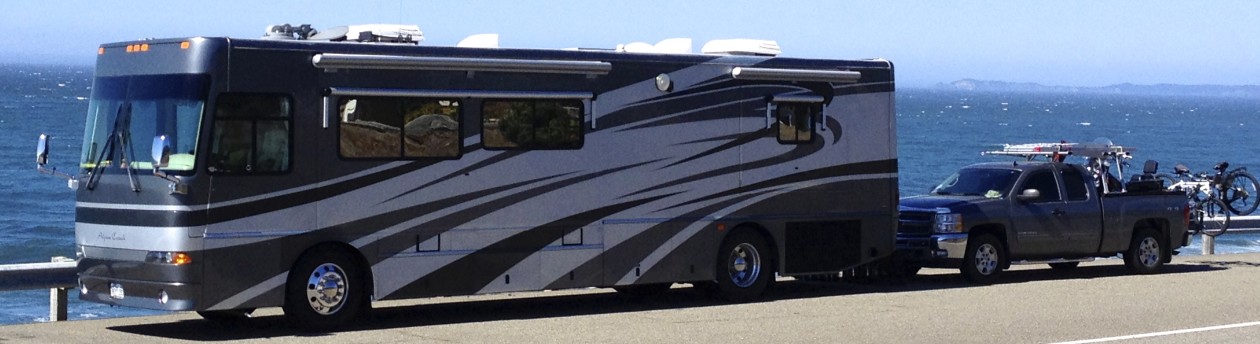
The Elks Lodge in Farmington is at the top of a hill overlooking the police station, and not unlike the lodge in Santa Fe – there were no signs to the RV lot 🙁 We had to pull into a parking lot at the bottom of the hill to unhook the Silverado so we could scout out the best access… the turns were tight and parked cars in the adjacent lots made it difficult.
And here we are… $15 per night for 30 Amp power and water hookups. No sewer though. And the 30 Amp power is a little ‘iffy’… it waivers between 105 and 113 volts and if we turn on one of the air conditioners it drops down to 103 or 104 volts. The Coach’s power monitor displays “Lo Power” and disconnects. I talked to our neighbor, but he says his power is good. Maybe it’s just our pedestal. I don’t want to move. We’ll just have to “rough-it” I guess, and we’ll take little Coach with us in the truck if we go anywhere.
We went into the huge lodge to pay for our site and ended up having tacos and wings for dinner. This is probably the largest lodge we’ve visited to date. Very friendly folks here and our second drinks were free per Elks Lodge custom.
Main entrance of Elks Lodge 1747 as viewed from the inside lobby at the top of the stairs.Bar area of Elks Lodge 1747.Game room at Elks Lodge 1747.
Thursday was another full day of sight-seeing and picture taking… We checked out a couple of the pueblo indian sites (ruins) and went over to Navajo Lake. So follow along…
Our first stop on Thursday was Salmon Ruins(←click link). We took our little dog “Coach” along for the day and found out this place is dog-friendly 🙂
We paid an $8 entrance fee for the two of us with military discount.
The visitor center didn’t have a theater but offered a nice interactive video display that described the site.
We were given an illustrated trail guide in paper format to take along with us on our self-guided tour.
We walked out the back door of the visitor center and down the path to Heritage Park which is a series of connected pathways that join reconstructed buildings that represent the different house types of the peoples and cultures of New Mexico from prehistoric through early historic times.
The website describes it so; “The exit near the Gift Shop brings visitors onto a shaded deck, the first of many picnic areas, and the start of a paved trail down the hillside to access the outdoor areas of the site: Heritage Park, the Salmon Family Homestead, and of course, the Chacoan outlier known as Salmon Ruins.”
This is the view back up to the visitor center from the Heritage Park below.
Follow along on our walking tour:
Reconstructed Pithouse.
Old Trading Post.The old Salmon homestead.Bunkhouse.Old homestead ‘relics’ on display in front of the bunkhouse.
After our walk through Heritage Park, we got to the ruins themselves…
The picture (below) from the illustrated guide book we were given at the visitors center depicts how the same building (shown in my picture above) used to look in the early 1900’s.
And this picture (above) is also illustrated once again in the following picture from the guidebook. It describes how the sun lines up on the altar during the solstice which I found interesting.
One of the many Kiva’s:
After our tour of the Salmon Ruins, we drove the 13 miles to the Aztec Ruins.
The Aztec Ruins (←link here) visitors center (below).
We parked in front of the visitors center in what little shade we could find. I also put the cover on the Harley which I try to do often whenever we park for any length of time.
This site (Aztec Ruins) is a national monument, unlike the previous site we just visited (Salmon Ruins) which is owned by the San Juan County government, and managed by the San Juan County Museum Association, an independent 501(c)(3) non-profit organization. What all this means is that they’re not dog-friendly, so we had to leave little Coach in the truck with the windows down. I don’t think we’ve come across a single national park or monument in our travels yet that is dog-friendly 🙁 The one “good” thing about this being a “national” monument is that I was able to use my disabled veteran access pass to get us in at no cost.
We toured the visitors center quickly…
and watched a 16 minute video in the mini-theater…
This visitors center also had an interactive monitor that described the site, just like the one at Salmon Ruins.
We were also given an illustrated guide book (just like at Salmon Ruins) to take along with us on a self-guided walking tour. But this guide was fancier than the one at Salmon Ruins, it was plastic coated and spiral-bound.
The Great Kiva at Aztec West (pic above and below) is the third largest kiva ever excavated. It was reconstructed by archeologist Earl Morris in 1934.
The AmericanSouthwest.net website (←link here) gives the best description of these ruins (in my opinion) and is well worth the read.
This mat of willows sewn with yucca cord (below) is over 800 years old.
The picture (above) is illustrated in the guidebook (below).
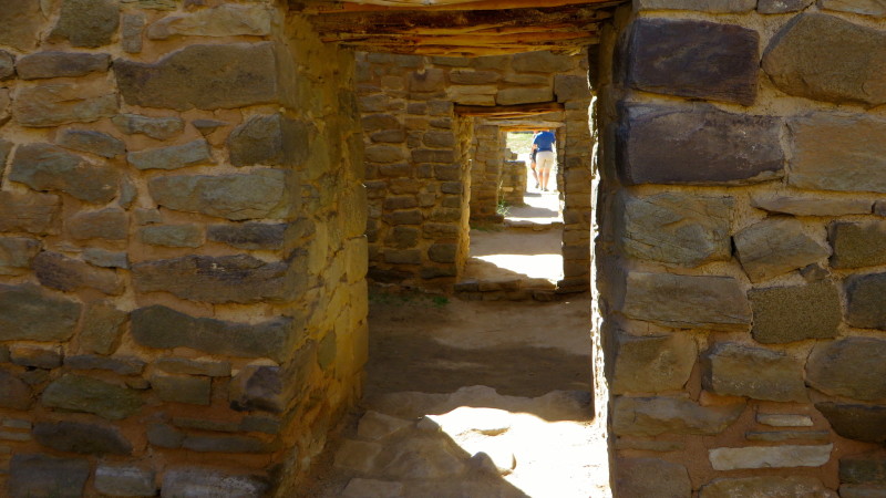
This is one of the very few ruin sites that still have intact roofs… we went (hunched over) through quite a few doorways in the dark.
View of the mysterious green stripe of greywacke stone along the western wall of Aztec West.
A couple more views of the plaza and ruins:
View of the visitor center (back-side) as seen from the ruins.
We breezed through the ruins quickly because it was hot and we had little Coach waiting for us. He was happy to be out of the truck. Here he is enjoying some shade.
We continued on our tour of the area… since we were only 27 miles from Navajo Lake State Park, we plugged it into the GPS. I remembered to take the Rand McNally RVND™ 7720 from the Coach this time.
We took scenic Hwy 173 west…
until we arrived at the bottom of the dam.
According to Wikipedia®: “The Navajo Dam is 402 feet (123 m) high and 3,648 feet (1,112 m) long. Its crest is at an elevation of 6,108 feet (1,862 m).[4] The reservoir formed behind the dam, Navajo Lake, is 35 miles (56 km) long and stores 1,708,600 acre feet (2.1075 km3) of water. The dam has one spillway, an ungated concrete chute capable of discharging 34,000 cubic feet per second.”
We drove up to the top of the dam…
and stopped at the top…
to view the spillway…
Top of the spillway at Navajo Dam.Spillway at the top of Navajo Dam (looking towards lake)
Views of Navajo Lake:
We drove over to the state park. The Navajo Lake State Park website says; “Navajo Lake is the second largest lake in the state, with multiple campgrounds, two marinas, and two boat docks. Navajo is a haven for boaters of every stripe – motorized boaters, canoers, kayakers, water skiers and sailors.”
We checked out the campground for future reference. Here’s the fees:
And here’s the campground loops:
Most of the sites seemed pretty small. We’d be hard-pressed to fit the Urban Escape Vehicle in here.
The visitors center was closed. A mobile trailer is performing temporary duty.
We drove over the top of the dam…
and continued on back towards Farmington on a different route. We took Hwy 511 towards the town of Blanco.
Just after the dam, we passed the Elks Recreation Area sign. We heard that the Farmington Elks had a recreation area / campground here…
from this sign (below) that was posted on the bulletin board back at the lodge.
Unfortunately, it was getting late and the Elks Recreation area was still a couple miles down a dirt road, so we decided to leave it for another time.
We made it back to the Elks Lodge in time for an excellent prime rib dinner and called it a night.
On Friday, we drove around town some more and then went over to Angel Peak(←link here). But let me update you on that in my next post. We plan on moving to Page, AZ today (Saturday) to get ready for the upcoming Alpine Coach Rally. Stay tuned…


