It’s wet, cold, and raining in Prescott Valley this morning (Monday), so we’re just hunkering down… we got here on Friday and I’ve used the last couple days to play catch-up on the blog since we didn’t have connectivity during our week-long stay at Alamo Lake State Park. Now let me bring you up to date on our time here so far…
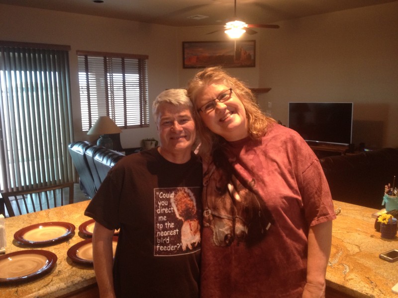
Scott and Julie Richardson inside their retirement ranch.
It’s great to see Julie again… we haven’t seen her since May of last year at her retirement party in Colorado Springs. After we arrived on Friday afternoon, we got caught up on recent events and old times a little bit and shared what little knowledge we had about mutual acquaintances’. We also got the “grand tour” of Scott and Julie’s beautiful home, aka., “Richardson Retirement Ranch” or (3R).
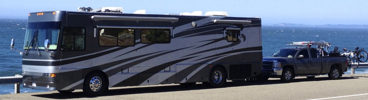
We parked the Urban Escape Vehicle in front of the 3rd garage so we wouldn’t block the driveway. Then we ran an extension cord to the garage outlet so we wouldn’t have to run our generator to charge the batteries.. the residential-type refrigerator sure sucks them down. Thanks for the juice Scott and Julie! And also the moochdocking, – er, I mean boondocking spot!
On Saturday, we took a little driving tour to catch some of the sights in the area. Julie acted as our tour-guide and we all piled into her car. We went north on AZ-89A aka the “Prescott Jerome Hwy” towards Sedona. We hadn’t gone very far up the winding pass before we spotted snow on the higher mountain tops around us. Ugh… thought we’d left that behind in Colorado.
We stopped to enjoy the view at a pull-out. It was windy but not raining yet.
When we got to Jerome, AZ, we decided to park and walk around a bit… what a neat town nestled on the hillside.
Here’s a pic I swiped from Google Images:
And here’s some actual pics we took while wandering around a bit.
Anyone recognize the lamp in the window?
We heard that the hotel in the pic below is supposed to be haunted.
We drove on down the pass and finally rolled into the picturesque town of Sedona. (don’t forget to click on the link for more info).
As you can see below, the rain picked up once we arrived in Sedona.
The rain didn’t stop us from shopping for some t-shirts though…
We passed by Pink Jeep Tours, who has quite a large fleet… and the crummy weather didn’t appear to be stopping tourists from lining up to take tours in the rain.
How about a couple more pics of the area:
Our downtown area walk was cut short with a brief downpour that made us dash for the car, so we headed on over to the Golden Goose Cafe & Bistro for a late lunch / early dinner. Scott and Julie treated… thanks again guys, you didn’t have to do that.
After our fine dining experience, we drove over to the nearby Chapel of the Holy Cross. Don’t forget to click the previous “green” link to go to the official church website, or here for more pictures from Google.
We were able to park in the upper lot and made the short walk to the semi-circular walkway up to the chapel.
Stilla, Julie, and Scott on the walkway up to the church.
The views from inside the church windows looking out – were awesome.
And here’s some views from the landing in front of the church entrance.
After visiting the picturesque church, we continued south on (also) picturesque route 179 until we got on I-17 which we took to the 169 exit, and then back to the house, effectively completing our loop for the day.
On Sunday, we stayed close to the area. Our highlight for the day was a trip to the local IN-N-OUT Burger. Yummm. This time Scott and Julie allowed us to treat. Julie acted as our chauffeur once again. Thanks Julie!!
Then we drove through the Bob Stump VA Medical Center… reminded me of an old Army base stuck in the ’50s. Check out the officer’s housing area:
Unfortunately, the museum here was closed.
In downtown Prescott, we stopped briefly in the rain for a picture of the courthouse. The crummy weather prevented us from wanting to wander around.
Then, on the way back home, we stopped at the Phippen Museum for a little “Art and Heritage of the American West”.
However, only a small portion of the museum was currently open for viewing due to new exhibits being put into place. So we opted to save our $7 per person entrance fee for another time and just browsed the gift shop.
Then we headed back to the house to relax again and hide out from the rain.
And that brings us to the present… here it is Monday (my new favorite day of the week since retirement) and it’s still raining outside. It rained all night, and it’s even been snowing a little bit this morning. At least it’s not sticking.
So we plan on just staying inside to wait out the weather. There’s a lot of cool stuff to see around here, but none of it’s quite so fun to do in the rain and cold.
As a parting shot… Julie shared this picture of an eagle with me that she saw in the back yard just the other day. We haven’t seen it since though… probably hiding from the cold weather like we are 🙂
We made it back to Scott and Julie Richardson’s house this evening (Sunday) after enjoying the day with them touring the area. I’ll post about that shortly.
But first, I have to bring you up to date on the rest of our time at Alamo Lake State Park. As I mentioned in my last post, the reason I got behind is because internet connectivity at the lake was almost non-existent. So, to continue on where I left off in my last post from this morning, here’s what we did…
21 Feb (Saturday):
We got invited to go ATVing with some other campers that we got into conversation with the day before. So we graciously accepted their invitation and met the group first thing in the morning. We carried our little dog “Coach” in his doggie backpack. And off we went…
There were seven ATV’s in the group altogether and our first destination for the day was going to be the “Mud Cliffs” that you can see on the right side of the hand drawn map (below) that we got from the ranger station. Our start point is labeled “Camp C” in the lower center of the map.
Stilla took some pics while riding on the back.
And here are the Mud Cliffs.
We rode through the sandy bottom of the gorge between the impressive cliffs.
The trail got smaller and smaller as the cliffs closed in on each side. Most of the group waited at the entrance to the cliffs because they had been there before and many of the side-by-side ATV’s were too wide to make it very far without getting stuck anyway.
We rode until the trail was blocked.
Then we parked and walked a little ways further up the canyon.
Stilla posed (at a safe distance) under an arch that looked like it could collapse at the first hint of rain.
After our “Mud Cliffs” adventure, we rejoined the rest of the group and headed further east. The destination was supposed to be a magnesium mine that some in the group had an agenda to see. However, during a short rest break, one of the side-by-side ATV’s wouldn’t restart. So we ended up spending the next hour or so troubleshooting the problem. We finally got it restarted but it was getting late so everyone decided to head on back instead of continuing on to the mine.
We got back in time to stop at the “Wayside Inn” before they closed for the day. This little bar and grill is in the middle of nowhere but they still manage to serve up great burgers and fries. They also have the only gas for sale within 35 miles.
Little “Coach” was happy to run around a bit after a long day of riding on the ATV. We had gone about 55 miles for the day and still had a few more miles to get back to the campground.
The “Wayside Inn” A small campground bar and grill – miles from nowhere.
One of the other riders in the group had a Can-AM ATV just like ours. His was a year newer than our 2007, but it was the same silver “limited-edition” series… the first one I’ve ever seen like ours. I took a couple pics and took note of how his mirrors are mounted because that’s something I’d like to add to ours in the near future.
We finished up our adult beverages (also available at the Wayside Inn) and motored on back to the campground to call it a day. And what a fun day it was!
22 Feb (Sunday):
We decided to spend the day (Sunday) on the lake to see if we could get some good use out of the $55 Arizona fishing license I purchased at the ranger station when we got here. So we broke out our Sea-Eagle inflatable raft that we keep in the back seat of the truck. It’s the SE-9 model called the “Fisherman’s Dream” with an electric trolling motor. We got ours from InflatableBoats4Less.com. The link to the SE-9 model we purchased is here.
We bought some live minnows at the ranger station / general store ($2.75 per dozen) and went to the boat ramp on the west-end of the lake to inflate the boat. After we got the boat into the water, we slowly motored our way to the other end of the lake while I trolled behind us with the minnows for bait. Unfortunately, by the time we got to the east-side of the lake, which is peppered with dead trees, the wind had picked up significantly. We were told that the “hot spot” for fishing was near the dead trees, however, an inflatable boat, no matter how sturdy, is no match for dead trees sticking up out of the lake… especially in high winds. So, we had to cut our day short and motor all the way back against the wind. We were worried the battery might not hold up, but luckily we were fine and didn’t have to flag down anyone for a tow.
Once we were safely back at the dock, we stored the trolling motor and battery, left the raft inflated and loaded it onto the back of the truck. We then released the remaining minnows on their own recognizance to fend for themselves in the dark waters of the lake.
Oh well, there’s always another day. You know what the say; “A bad day of fishing is better than a good day at work” 🙂
We spent the rest of the day hanging around the Coach. I used the time to give the ATV a good washing. Then I cleaned and serviced the K&N air filter after removing an old animal nest I found under the plastic cowling in front of the seat. A fellow camper gave me some of the “recharge” oil I needed to properly service the filter.
I know you’re disappointed, but there’s only one picture for the day.
It rained off and on all night.
23 Feb (Monday):
It was still sprinkling in the morning and it was chilly… I don’t think we’ve had temps this cold since we left Colorado. Another ATV ride had been scheduled with the same group we hung out with before, but everything was cancelled due to the poor weather.
We took the inflatable boat off the back of the pickup and drained out all the water it had collected overnight.
Then we decided to take the pickup out to the Wayside Inn to get our 5 gallon fuel can refilled, but that ended up being a short trip because the dirt road that goes out to the Inn was too muddy… I didn’t want to spend another day just washing the truck. We turned around and went back to the campground.
So we ended up taking another trip up to the dam to look for burro’s. We’ve heard the burros almost every night but haven’t seen any yet… Stilla wants to see some burros. Unfortunately for Stilla, no burros were to be found anywhere… just several road signs that say; “Watch for Burros”.
The rest of the day, we spent hanging around the Coach. At least the rain washed some of the dust off the Coach, so I spent some time wiping it dry once it stopped drizzling. Then we closed out the rest of the day with a lot of television.
24 Feb (Tuesday):
It was another chilly morning, but at least it was dry. We got invited to join a different group this time to do another ATV trip. The destination today was a giant Saguaro cactus that someone in the group had discovered on an earlier trip. This time, we left little dog “Coach” in the big Coach since it was supposed to be a long ride.
There were seven or eight ATV’s in our group today.
It was a long way out, but we finally arrived at the giant cactus.
Stilla posed for this picture which gives the huge cactus some perspective.
Pretty impressive, eh?
We then headed towards a distant mountain range… the goal was to see if there was a way across and then back to the campground. That goal was not realized…
Along our route to the mountain range, we stopped to explore around some abandoned mines.
Everyone had brought their own lunch which we stopped to enjoy after checking out the abandoned mines.
We then headed on up the mountain. Check out the long winding road in the picture below.
Here we can see the top of the mountain with all the antennae on top.
Getting closer to the top.
View back towards the lake… way in the background.
We ended up having to turn around at a gate near the top. At least the views were awesome. It’s a shame we couldn’t make it all the way up, or even better, down the other side. The GPS said we had attained an altitude of ~5,200 feet above sea level.
We stopped at the Wayside Inn on the way back. We must have been on fumes after traveling over 70 miles for the day. The fuel gauge was showing empty for miles before we finally rolled in. They close at 4 PM on weekdays, so we were especially lucky to have made it back on time, just as they were closing. Another good day!
25 Feb (Wed):
Today (Wednesday) was another full day of ATVing. We met John the first day we got here and he was with the group from yesterday when we visited the giant cactus. He and his wife offered to take us to the north side of the lake to “Red Canyon”. We took little “Coach” along with us today.
We crossed to the north side of the lake by going through the marsh-like river bed on the east side.
It was dry where we crossed the river, the water was running underground. John said they had to ford through at least six inches to a foot of water when he crossed last week.
After an hour or so we finally reached the “Red Canyon”. Here’s some pics for your viewing pleasure…
We even explored a couple side canyons, but most just dead-ended like this one.
This is truly a “must-see” canyon… and super fun to ride through. We’re going to have to come back here sometime in the future to explore of the area, we only scratched the surface from what we’ve been told. We ended up going about 50 miles for the day.
26 Feb (Thursday):
It was time to give the fishing another try. Today, the water was calm with very little wind. We stopped at the ranger station / general store to get some more minnows on the way to the boat launch. We met a guy that was checking out of the campground and he offered to give us his remaining minnows. I thanked him and we hit the lake.
Stilla thought it would be funny to take a picture of my catch. Really, it’s the bait minnow ready to go into service and do his duty.
This time, we stayed on the west side of the lake and didn’t worry about trying to go around the dead underwater trees on the east side. We didn’t want to get caught too far away from the boat launch if the wind picked up again… plus, we didn’t want to fight for space with the other fishermen in their boats.
After an hour or so, I hooked a fairly large fish, but it got off the hook just as Stilla was putting the net in the water. Bummer.
But it wasn’t too long before I landed another one.
It was a male crappie according to a fellow fisherman and our ever-helpful friend; Wikipedia.com.
It was a slow fishing day according to other fishermen that I talked to later. But at least I didn’t get skunked this time 🙂
We cleaned the fish back at our campground at the fish cleaning station with the help of yet another friendly fellow camper that was an experienced fisherman. We got some pretty nice filets for the freezer.
Here’s a final parting shot of the lake, since this is our last day here.
Tomorrow, we plan on moving on, as our weeklong reservation concludes.
And Stilla finally got a picture of some of the local burros. So she’s happy too.
Goodbye and good evening from Alamo Lake State Park. We’ll be back!
27 Feb (Friday):
We left the state park after driving the Coach over to the dump station and taking care of business there. Tire pressures are all still holding… no more slow leaks, at least for now.
Once we drove the 35 miles or so to get back to highway 60, we expected our AT&T service to be back on. But, alas, it was not to be… it seems we used all our “off-network” allowance and can only connect once we get an actual AT&T 3G signal. At least we can still make phone calls, but I guess we’ll have to wait until the end of our billing cycle to get the “off-network” ability reset in order to use WiFi or google maps, etc.,
We decided to head east on 60, and since we were this close to Prescott Valley where my good friend and former coworker (Julie Richardson) now lives, I gave her a call to see if we could stop by.
After ~150 miles, and the help of google maps, we made it to Scott and Julie Richardson’s beautiful retirement home. And guess what – there’s a strong AT&T 3G signal here!
I’ll post more about our visit here at the “Richardson Ranch” later. Stay tuned…


